|
|
||
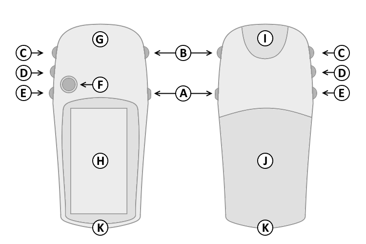
| A. | Power | |
| B. | Page | |
| C. | Up | |
| D. | Down | |
| E. | Menu/Find | |
| F. | Select/Enter/Mark | |
| G. | GPS Antenna | |
| H. | Monochrome Display | |
| I. | Power/Serial Data Port | |
| J. | Battery Cover | |
| K. | Lanyard Attachment | |
|
|
||
| A. | Power | |
| B. | Page | |
| C. | Up | |
| D. | Down | |
| E. | Menu/Find | |
| F. | Select/Enter/Mark | |
| G. | GPS Antenna | |
| H. | Monochrome Display | |
| I. | Power/Serial Data Port | |
| J. | Battery Cover | |
| K. | Lanyard Attachment | |
| A. Power Button | D. Down Button | |
| 1. Press and hold to turn unit on/off. | 1. Select page and menu options. | |
| 2. Press and release to cycle the display backlight on/off. | 2. Zoom In on the Map page. | |
| B. Page Button | 3. Adjust contrast (lighter) in the Satellite page. | |
| 1. Press and release to loop through display pages. | 4. When on a list, press to jump to last item and page down. | |
| 2. Press and release to exit/quit a function. | E. Menu/Find Button | |
| C. Up Button | 1. Press and release to view option menu for active page. | |
| 1. Select page and menu options. | 2. Press and release twice to view Main Menu. | |
| 2. Zoom Out on the Map page. | 3. Press and hold to display the Find Menu. | |
| 3. Adjust contrast (darker) in the Satellite page. | F. Select/Enter/Mark Joystick Button | |
| 4. When on a list, press to jump to first item and page up. | 1. Press and release to confirm data entry or menu selections. | |
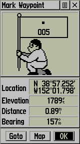
| 2. Press and hold to activate Mark Waypoint page. | ||
| 3. Move up, down, right or left to navigate menu selections or pan map arrow. | ||
 |
 |
 |
 |
| Satellite | Map | Navigation | Trip Computer |
 |
 |
 |
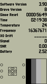 |
| Main Menu | Mark Waypoint | Software Version | Diagnostic Screen |
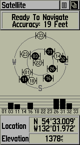
The Satellite page displays satellite identification and signal strength information.
The upper data field displays GPS Status and estimated location accuracy.
The lower data field shows current location and elevation information.
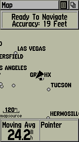
The Map page displays your present position and direction of movement using a triangular 'Position Icon' that is centered on the map.
A status window at the top of the screen displays current satellite tracking and accuracy information.
The map provides a picture of where you are, where you are going (path to destination), where you have been (track log), waypoint names and symbols and other map information.
Press and hold the Up (C) or Down (D) buttons to change the map scale as desired.
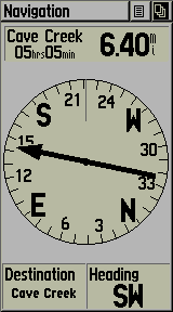
The Navigation page helps guide you to a destination.
When moving without a destination selected, the upper data field displays GPS Status and estimated location accuracy. The compass ring displays your heading while moving.
When moving with a destination selected (navigating), the upper data field shows the name, distance and time to the current destination. Simply follow the compass arrow to find your destination.
To change data fields, use the Joystick Button (F) to select the Options Menu, then select the desired data field and choose from available Trip Computer data:
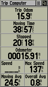
The Trip Computer page displays up to nine different types of navigation data.
Each data field is user configurable.
To change data fields, use the Joystick Button (F) to select the Options Menu, then select the desired data field and choose from available Trip Computer data:
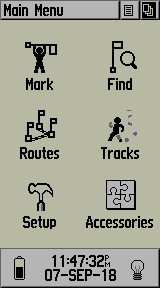
The Main Menu page provides access to advanced features and settings.
Move the Joystick Button (F) to highlight the desired menu selection.
Press the Joystick Button (F) to activate the highlighted menu selection: